
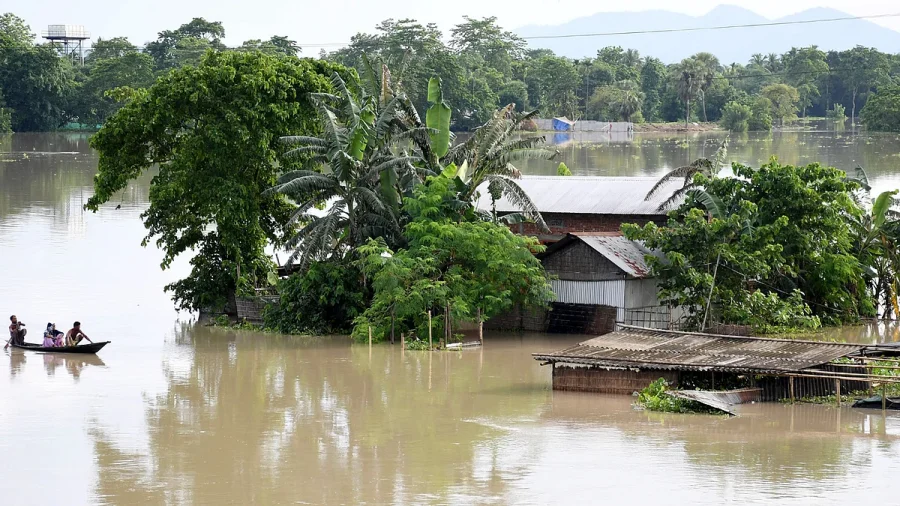
The sight of submerged villages, families clinging to rooftops, and swollen rivers swallowing entire districts has become a recurring nightmare for Assam. But this year, the devastation feels unprecedented. With 58 lives lost, nearly 7 lakh people affected, and vast tracts of Upper Assam still under water, experts say this is not just another monsoon tragedy – it is a crisis born from a dangerous convergence of extreme weather, climate change, and centuries of human interference with the region’s rivers.
The Catastrophe in Numbers: 58 Dead, 7 Lakh Affected
According to official reports, the floods have engulfed 856 villages across 12 districts. Over 1.15 lakh people have been forced into relief camps, while thousands more are stranded. The districts of Sivasagar, Charaideo and Jorhat have borne the brunt, with entire communities cut off from road access.
Rescue teams from the National Disaster Response Force (NDRF), the Army, the State Disaster Response Force (SDRF), and Fire and Emergency Services have conducted multiple operations. Yet, Chief Minister Himanta Biswa Sarma has acknowledged that relief teams are still struggling to reach the most remote areas.
Why This Flood is Different: The Science Behind the Disaster
This is not a routine monsoon deluge. Meteorologists point to an unusually intense and prolonged spell of rainfall over the upper Brahmaputra catchment in recent weeks. But rain alone does not explain the scale of the disaster. What makes this flood unique is the region’s drastically reduced ability to absorb water.
The rivers of Assam, especially the Brahmaputra and its tributaries, have lost much of their natural flood-plain capacity. Decades of embankment construction, deforestation, and encroachment on wetlands have narrowed channels and forced water to rise higher and spread farther.
Climate Change Meets Human Intervention: A Lethal Combination
Environmental experts argue that two forces are colliding. First, climate change is intensifying the monsoon – bringing heavier rainfall in shorter periods. Second, human actions have degraded the natural buffers that once allowed rivers to overflow safely. Wetlands that used to absorb excess water have been drained for agriculture and settlements. Sand bars and river islands have become densely populated, leaving communities extremely vulnerable.
“We are seeing the result of a system where the rivers have nowhere to go,” one hydrologist told the press. “The water rises, finds the weakest points in embankments, and then spreads uncontrollably.”
Upper Assam: Ground Zero of the Crisis
The Upper Assam region – home to tea gardens, wildlife sanctuaries, and towns like Jorhat and Sivasagar – has been hit hardest. Why? Because this is where the Brahmaputra and its tributaries narrow and slow down, depositing silt that raises riverbeds. When heavy rain comes, the water simply overflows the banks.
Nearly 70% of the reported deaths have occurred in these districts, with many victims being elderly or children who could not escape in time.
Relief Efforts and What’s Still Missing: Official Response
Chief Minister Himanta Biswa Sarma has been personally monitoring operations. The state government has set up over 250 relief camps and distribution centres. However, he admitted that “relief teams have yet to reach some villages due to breaches in road connectivity.” The NDRF has deployed additional boats and teams, but the sheer scale of the inundation has stretched resources thin.
Opposition leaders have criticised the government for being slow in pre-monsoon preparedness, while the administration insists that the intensity of the floods was beyond normal forecasts.
The Human Toll: Stories from the Relief Camps
Inside the camps, families speak of losing everything. Paddy fields, livestock, and homes lie under murky water. Many have been displaced multiple times in the last five years, compounding trauma. “This is the worst I have seen since 2004,” an elderly resident of Sivasagar said. Children are missing school, and there are growing concerns about waterborne diseases like diarrhoea and leptospirosis.
The emotional cost is heavy, and for many, the question is not if the next flood will come, but when.
Confirmed Facts vs What Remains Unclear
Confirmed: 58 deaths (official toll), 7 lakh+ affected, 856 villages inundated, relief operations underway, CM acknowledged incomplete reach. Unclear: Total economic damage, exact number of missing persons, long-term effectiveness of existing embankments, and whether early warning systems fully functioned. Official data is still being compiled from remote villages.
The Role of Dams and Embankments: A Double-Edged Sword
For decades, Assam has relied on embankments to contain rivers. But these structures have become part of the problem. They confine water to ever-narrower channels, increasing pressure. When breaches occur, water bursts through with greater force. Upstream dams in neighbouring states also alter flow patterns, sometimes releasing water without adequate warning.
Experts suggest that a hybrid approach – restoring wetlands, allowing controlled flooding in designated areas, and building raised community shelters – may be more sustainable than building higher walls.
Risks and a Fragile Future
The immediate risk is a second wave of floods as monsoon continues. Stagnant water is causing outbreaks of skin infections and diarrhoea. There is also the danger of landslides in nearby hills. In the long term, climate projections indicate that Assam will face more intense rainfall events, making the current crisis a preview of what could become the new normal.
Critics point out that the state’s master plan for flood management has been delayed for years. Without urgent implementation, each monsoon will bring similar – or worse – devastation.
A Wider Pattern: Assam’s Recurring Flood Cycle
Assam has always been a flood-prone state, but the frequency and severity are increasing. Data from the Assam State Disaster Management Authority shows that in the last decade, large-scale floods have occurred every two to three years instead of every five to seven. This year’s event fits that pattern, exacerbated by an unusually active monsoon trough.
The situation is also mirrored in other parts of South Asia – from Bangladesh to Nepal – where a combination of climate change and unplanned development is creating similar crises.
What Residents Should Do Now: Practical Guidance
For those in affected areas, officials urge people to move to higher ground immediately, avoid walking through floodwater due to hidden hazards and contamination, and use only boiled or treated water. Families are advised to keep emergency contacts for NDRF (011-24363260) and local helpline numbers ready. Those in relief camps should follow hygiene protocols to prevent disease outbreaks.
Non‑affected communities can help by donating to verified relief organisations and avoiding the spread of unverified rumours about rescue operations.
Future Outlook: Can Assam Build Resilience?
Short-term relief is the priority, but long-term solutions are now a necessity. The Assam government has announced a comprehensive river management plan that includes restoring wetlands, reinforcing embankments with smart sensors, and creating flood‑resilient housing. However, funding and political will remain challenges.
Scientists stress that upstream coordination with neighbouring states and countries is essential. Without basin‑wide management, Assam will continue to bear the brunt of a system it cannot control alone.
Our Take
This is not merely a natural disaster – it is a man‑amplified one. The tragedy in Upper Assam is a stark reminder that climate change and human modification of landscapes are not separate threats; they reinforce each other. While relief efforts deserve credit, the larger lesson is that prevention must move beyond piecemeal embankments to holistic, science‑based planning. The lives lost are not just numbers – they are a warning that we are running out of time to rethink how we live with rivers.
Frequently Asked Questions
Why is Assam experiencing one of its worst floods this year?
Because of a combination of extreme monsoon rainfall, climate change intensifying storms, and human activities such as building embankments and draining wetlands that have reduced the rivers’ natural capacity to absorb floodwaters. The Upper Assam region is particularly vulnerable due to siltation and narrow river channels.
How many people have died and been displaced in the Assam floods 2024?
As per official data, at least 58 people have died and over 7 lakh people have been affected across 856 villages in 12 districts. More than 1.15 lakh people are staying in relief camps.
What relief measures are being taken by the government?
The state government, along with NDRF, Army, SDRF, and local authorities, is conducting rescue operations and running over 250 relief camps. Chief Minister Himanta Biswa Sarma has acknowledged that some areas remain unreachable due to road damage. Food, water, and medical aid are being distributed.
What can people do to stay safe during Assam floods?
Move to higher ground, avoid walking through floodwater, drink only clean water, and follow official instructions. Keep emergency helpline numbers (NDRF disaster helpline: 011-24363260) handy. Do not spread unverified information about rescue efforts.