Summary
New satellite images have provided clear evidence of the massive destruction in southern Lebanon. An analysis of these images shows that more than 1,400 buildings have been destroyed since early March. The damage is concentrated in villages near the border, where entire neighborhoods have been turned into rubble. This report highlights the growing physical cost of the ongoing conflict and the long-term impact on the people who live in these areas.
Main Impact
The primary impact of these demolitions is the total loss of housing and infrastructure for thousands of people. When buildings are destroyed on this scale, it is not just about losing a roof over one's head; it is about the destruction of entire communities. The scale of the damage suggests that these areas will be uninhabitable for a long time, even if the fighting stops tomorrow. This creates a massive challenge for future recovery and leaves many families with no home to return to.
Beyond the loss of homes, the destruction affects schools, shops, and local services. This makes it very difficult for any remaining residents to survive and discourages those who have fled from coming back. The physical change to the border region is so severe that it may permanently alter the way people live and move in southern Lebanon.
Key Details
What Happened
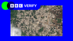
The destruction was identified by comparing satellite photos taken at different times. By looking at images from before and after March 2, experts could see where buildings used to stand and where there is now only debris. In many cases, the images show that buildings were not just hit by shells or missiles but were completely leveled. This often happens through controlled explosions or the use of heavy machinery to pull structures down.
The analysis focused on several villages along the border. In some locations, almost every building in a specific area has been flattened. The photos show large brown patches of dirt and broken concrete where rows of houses once stood. This systematic approach to clearing buildings indicates a deliberate effort to change the physical environment of the border zone.
Important Numbers and Facts
The data shows that at least 1,400 structures have been wiped out in a period of about six weeks. This number includes private homes, agricultural buildings, and commercial properties. The analysis was conducted by BBC Verify, a team that uses data and visual evidence to check facts. They used high-resolution images from commercial satellites to count the individual buildings that were no longer standing. The timeline of this destruction began on March 2 and has continued steadily through the middle of April.
Background and Context
This topic is important because it shows the reality of war away from the front lines of fighting. The border between Israel and Lebanon has been a place of tension for many years. Recently, the conflict has grown more intense. Israel states that its military actions are necessary to remove threats and stop groups like Hezbollah from using these buildings for military purposes. They argue that clearing these areas helps protect their own citizens from cross-border attacks.
On the other side, Lebanese officials and international observers argue that the destruction is too broad. They say that many of the buildings being destroyed are civilian homes that have nothing to do with military activity. This debate is central to the conflict, as it involves questions about international law and the protection of people who are not involved in the fighting.
Public or Industry Reaction
The reaction to these satellite images has been one of deep concern. Human rights groups have pointed out that destroying homes on such a large scale can be a violation of international rules. They worry that this is a "scorched earth" strategy, which means destroying everything so the enemy cannot use it, but also making it impossible for civilians to live there. Lebanese leaders have called the actions a crime against their people and have asked the international community to step in.
In Israel, the military maintains that its operations are targeted and necessary for national security. Some security experts argue that creating a clear zone along the border is the only way to prevent future ground attacks. However, some critics within the region worry that this level of destruction will only lead to more anger and more conflict in the future.
What This Means Going Forward
Looking ahead, the cost of rebuilding these villages will be billions of dollars. It is not just about building new houses; it is about replacing water pipes, electricity lines, and roads that have been crushed. This will require a massive international effort and a stable peace agreement, neither of which are currently in place. For the families who lived in these 1,400 buildings, the future is very uncertain. Many are living in temporary shelters or with relatives in other parts of the country.
There is also a risk that this destruction will lead to a permanent "no-man's land" along the border. If people cannot return to their land, the area may become a permanent military zone. This would change the map of Lebanon and could lead to long-term displacement for tens of thousands of people. The next steps will depend on whether a ceasefire can be reached and if there will be a plan to help people move back and rebuild their lives.
Final Take
The use of satellite technology has made it impossible to hide the scale of destruction in southern Lebanon. With over 1,400 buildings gone in just a few weeks, the physical evidence shows a region that is being systematically dismantled. While the military reasons for these actions are debated, the human cost is clear. The loss of these homes represents a deep scar on the region that will take decades to heal, long after the current fighting ends.
Frequently Asked Questions
How was the destruction of the buildings confirmed?
The destruction was confirmed using high-resolution satellite images. Experts compared photos taken before March 2 with more recent images to identify and count buildings that had been leveled or severely damaged.
Why are these buildings being destroyed?
The Israeli military states that it is destroying buildings used by armed groups for military purposes. However, Lebanese officials and residents say that many of the structures are civilian homes and essential community buildings.
Can the residents return to their villages?
Currently, it is very difficult for residents to return because the buildings are gone and the infrastructure is destroyed. Even if the fighting stops, the lack of housing, water, and electricity makes these areas unsafe for living.